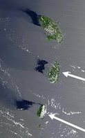
 Islands in the Bermuda Triangle were photographed levitating by as much as 10 miles off the surface of the ocean in this recently-declassified image from a U.S. spy satellite. Click on the image for a larger picture.
The islands are located in a large region popularly known as the Bermuda Triangle. The spy satellite imagery clearly shows shadows cast by two of the islands on the ocean surface in such a way that can only be explained if the islands are levitated above the ocean surface, in one case by approximately ten miles.
Link & Image: EcoEnquirer via Presurfer
Tags: Island | Levitating | Photograph | Photo
Comments
What you see in these pictures is the dark patch of different sea conditions in the lee of the island. As Mark G points out, islands don't just sit on the sea, they continue to the seabed.
If these were shadows of 'levitated islands' the shadows would retain a rather more accurate correlation to the island's shape. Whichever idiot is so incapable of interpreting aerial images as to imagine he's found evidence of levitation, deserves a slap in the face with a wet kipper.
the two idiots posted some intense shed-off comments before thinking.
the darkness is not because of different sea conditions. see the wind blocked by possible levitating islands and therefore the darkness (instead of spread whiteness) where water is not being pushed by strong winds.
Also the darkest island contour sized patches can only be explained by levitaion concept.
all this was undiscovered till now and slowly as it is confirmed and explained better it will open up new chapters of science.
science is nothing dropped down through the sky.
its "discoveries consistently explained" and why do u think new theories are taken support of to explain new phenomenas which is unexplicable by existing sceience.
also the planes might be hitting these islands because usually they fly less than 10 miles height.
ships i cant think of why because of levitation ??